
- Science
- 16 de April de 2026
- No Comment
- 20 minutes read
The geological story of Gran Canaria
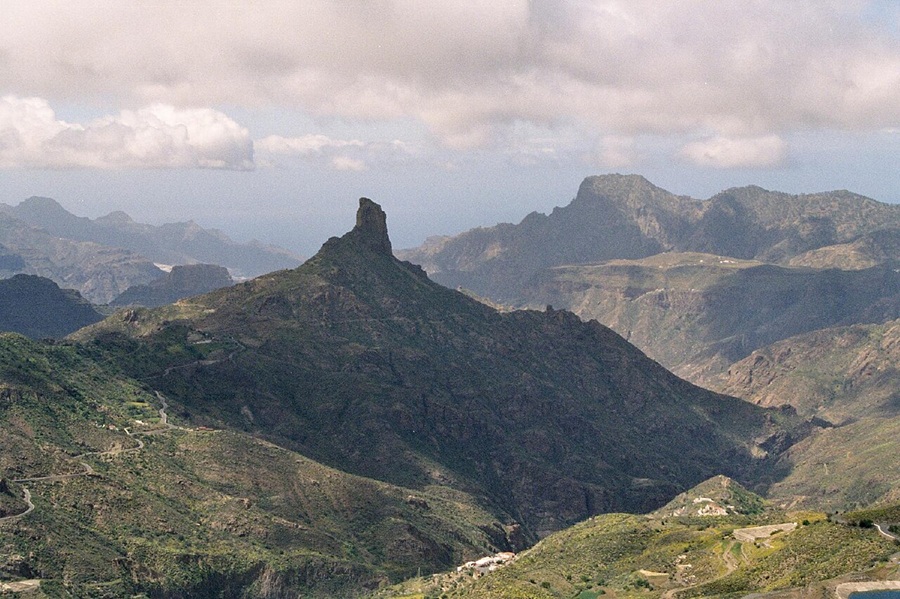
Roque Bentayga, Gran Canaria. / Source: Flickr. Author: Martin Wiesheu / Wikimedia: Andre Engels

This oceanic island is divided into two broad sectors separated by a NW–SE line that runs diagonally across it. The south-western sector contains the oldest part of Gran Canaria, shaped by Miocene eruptions. By contrast, the north-eastern sector is dotted with numerous local eruptions dating from the Pliocene and the Quaternary. At the heart of the island, like an immense ring, lies the Tejeda caldera. The entire structure is rooted in the ocean floor, reaching depths of around 3 km.
To understand this in detail, one must consider the different processes that have shaped Gran Canaria—from its submarine phase, which accounts for around 90% of its rock mass, to its emergence above sea level during the Middle Miocene, some 14 million years ago.
The evolution of a volcanic oceanic island involves both constructive processes (magmatic activity) and destructive ones (erosion and gravitational landslides). The submerged portions preserve the most information, yet they are also the least accessible to direct study. As a result, the exposed part of the island is the best studied, even though it represents only a small fraction of the whole—a classic case of the tip of the iceberg.
The submarine volcanism of Gran Canaria—known as the basal complex—accounts for more than 80% of the island’s volume. However, its age, structure and full extent remain uncertain, owing to the lack of subaerial outcrops; it can only be reconstructed from bathymetric and geophysical data. This submarine stage is estimated to have a volume of around 6,500 km³ and an age of roughly 15 million years.
Gran Canaria’s circular outline, about 46 km across, rests on an ocean floor some 3,000 m deep. Its highest point is Pico de las Nieves (1,949 m), near the centre of the island, from which a network of radial ravines spreads out across two clearly distinct domains. The western and south-western domain, which is geologically older, displays a deeply incised drainage network. The north-eastern domain, more recent, is characterised by younger Strombolian eruptions (less than 3 million years old) and a gentler relief, reflecting its more recent formation.
Gran Canaria is a geologically mature island, whose landscape bears more signs of erosion than of volcanic construction. Although it has remained active for at least the past 14 million years, there is no volcanic activity at present. Dark, dense magmas rich in iron and magnesium silicates (mafic, typically associated with fluid, effusive eruptions) gradually evolved into lighter, more viscous magmas (salic or felsic), richer in sodium and potassium silicates and linked to more explosive eruptive behaviour.
In its earliest stages, Gran Canaria grew from the ocean floor, with around 90% of its total volume formed during this phase. Only later did eruptions build an island above sea level, beginning around 15 million years ago. Three main stages can be distinguished.
The first involved the growth of a large shield volcano, probably formed by the merging of several basaltic shields. The second saw the development of a collapse caldera, followed by roughly 3 million years of reduced volcanic activity, during which erosion became the dominant process (Carracedo et al., 2002). The third stage was marked by renewed volcanic activity, which rejuvenated the landscape through new eruptive phases.
Over time, magma compositions became progressively more alkaline, in line with declining magma production rates and increasingly explosive eruptions. This is what gives Gran Canaria the greatest lithological diversity—and the highest proportion of salic rocks—of any island in the archipelago. Notably, alkaline rhyolites occur only here. In short, magmas became progressively more viscous, and eruptions correspondingly more explosive.
In more detail, as regards the subaerial growth of Gran Canaria, more than a hundred radiometric dates allow its development to be placed in chronological sequence and the three stages outlined above to be defined more precisely. On this basis, three more or less continuous volcanic cycles have been identified: Cycle I, or the Ancient Cycle (Miocene in age); Cycle II, or the Roque Nublo Cycle (Pliocene); and Cycle III, or the Recent Cycle (Plio-Quaternary). These are separated by intervals of volcanic inactivity and erosional activity. Cycle I corresponds to the initial shield-building stage, whereas Cycles II and III belong to the later rejuvenation stage.
Cycle I (Miocene)
This cycle, spanning roughly 14.5 to 8.5 million years ago, comprises the Ancient Basaltic Series, the Trachy-syenitic Complex and the Phonolitic Series, associated with the GüiGüi–Horgazales and Tejeda formations (Mogán and Fataga Groups), as well as basaltic and felsic rocks including trachytes, rhyolites and phonolites.
The earliest eruptions were Hawaiian in style, with relatively continuous lava outpourings and only limited interbedded pyroclastic material. These eruptions were fed by a network of pre-existing fractures, with three main eruptive centres: near Agaete (NW), south of San Nicolás de Tolentino, and near Agüimes (SE).
Following its emergence above sea level around 14.5 million years ago (Middle Miocene), rapid outpourings of basaltic lava produced more than 1,000 km³ of magma, building a volcanic edifice over 2,000 metres high and roughly comparable in diameter to the present island. A radial and convergent dyke pattern indicates that the centre of this edifice lay to the west of Tejeda.
During this growth phase (14.5–14.1 Ma), a major gravitational landslide affected the flanks of the volcano, as evidenced by the discordant contact between the GüiGüi and Horgazales formations. Such large-scale landslides are common on volcanic islands (for example in Macaronesia, Hawaii and Réunion). These large-scale movements are linked to the rapid uplift of volcanic islands: the higher the elevation, the greater the slope instability. In addition, the fragmentation of the island into fracture systems—forming, in plan view, Y-shaped or star-like patterns (volcanic rifts)—favours the development of these extensive sliding surfaces.
As the shield developed, and its flanks underwent sliding, the more viscous magmas that were still unable to reach the surface gradually accumulated at the base of Gran Canaria, at a depth of around 5 km. In this way, a magma chamber developed, fed by a deeper reservoir at approximately 14 km. In the long term, these more viscous materials triggered a series of highly explosive eruptions whose deposits spread across the entire island from around 14 million years ago.
These explosions deposited some 30 metres of rhyolites, trachybasalts and ignimbrites, collectively known as the Mogán Group. This group consists of 17 ignimbrite units deposited between 14 and 13.3 million years ago. The origin of these explosions lay in the depletion of the magma chamber, emptied during earlier eruptions, which led to the collapse of the cavity and the subsequent formation of the Tejeda caldera.
This large structure, measuring around 20 km from east to west and 17 km from north to south, displays inward-facing slopes of 40 to 45 degrees in its central sector. Subsequently, residual volcanic materials from the magma chamber (felsic in composition) continued to fill the depression through viscous magmas and highly explosive, violent Plinian eruptions (Fataga Group, 13.3 to 8.3 million years ago).
The upward pressure exerted by these magmas caused ring fracturing of the upper crust. Later, between 11.7 and 7.32 million years ago, within the Fataga Group, a series of conical felsic dykes (cone sheets) were emplaced at the base of the caldera. This structure became established in its central and deeper parts during the final eruptive pulses.
This conical structure, now exposed by erosion, formed an intrusive complex of ellipsoidal geometry, with a major axis of 13 to 14 km and a minor axis of around 10 to 11 km, centred beneath Roque Bentayga. Associated with the deep cone-sheet structure, further intrusions of granitoid rocks (syenites) developed, forming discontinuous outcrops around the cone-sheet and, in many cases, accounting for more than 90% of the currently exposed rock. Owing to their greater resistance, these syenites have undergone less erosion than the surrounding materials and now form extensive outcrops.
Following the formation of the Tejeda caldera, further explosive eruptions produced thick high-temperature pyroclastic deposits (ignimbrites). These magmas were rich in sodium- and potassium-bearing silicates, giving rise to rocks such as trachytes and rhyolites. These erupted materials covered both the exterior and interior of the caldera: the external deposits spread across large areas of Gran Canaria, while those emplaced within filled the Tejeda caldera.
Meanwhile, the magma chamber once again accumulated and concentrated more viscous residual material that was unable to ascend. This differentiation led to a further change in the chemical composition of the deep magmas beneath Gran Canaria. As a result, phonolitic deposits were generated between 13 and 9.6 million years ago—a light-coloured rock rich in sodium and potassium silicates. Their eruptive centres were located more or less close to the Tejeda caldera, giving rise to a large volcanic edifice in the central and south-western part of the caldera (the Cruz Grande stratovolcano). These phonolitic deposits covered much of the Tejeda caldera.
In summary, after an initial Hawaiian phase characterised by fluid magmas (14.5–14.1 million years ago), Gran Canaria evolved towards more viscous (felsic) compositions, culminating in explosive eruptions from the centre of the island, consisting of ignimbrite deposits together with trachytic, rhyolitic and phonolitic lavas (13.9–13.3 million years ago: Mogán Group).
In the final stages of this Cycle I, consolidation of the lava flows and their associated explosive products took place, accompanied by three intrusive episodes. The first involved granitoid rocks (syenites) emplaced in the central areas of the caldera (around 11.8 million years ago), contemporaneous with phonolitic eruptions. The second consisted of trachytic and phonolitic dykes which together formed an inverted cone (cone-sheet structure). These dykes cut through all earlier rocks, including the syenites, causing doming of the ground surface within their zone of influence. Finally, nepheline-bearing phonolitic domes developed, broadly following the outer limits of the cone-sheet. These intrusions represent the final manifestations of Cycle I, dated to around 8.5 million years ago.
It should be noted that felsic magmas, being much more viscous than mafic ones, ascend with greater difficulty; as they approach the surface and pressure decreases, they expand, fracturing the surrounding rock and often adopting cylindrical or dome-like forms. These deep-seated intrusive bodies are later exposed by erosion as volcanic plugs (“roques”).
Meanwhile, the north-eastern flank of the Miocene basaltic edifice of Gran Canaria had been significantly lowered relative to the outcrops along the western coast. Eruptive centres had shifted towards the Cruz Grande area, where a large phonolitic edifice developed in the central-south-western sector of the island. Subsequently, during the emission of these viscous (felsic) eruptions, intense erosion progressively reduced the relief of Gran Canaria, carving out a radial network of large ravines, with only occasional residual phonolitic intrusions remaining.
This erosion produced large quantities of sands and alluvial conglomerates, which were deposited in lower-lying areas between 8.3 and 5.3 million years ago, forming the Las Palmas Detrital Formation (LPDF). This formation crops out in the vicinity of the city of Las Palmas and, more locally, in the southern part of the island. With this, the first volcanic cycle of Miocene age came to an end.
An eruptive hiatus between the first and second cycles resulted in a prolonged period of volcanic inactivity lasting around 3.2 million years, but marked by intense erosion, as evidenced by the detrital deposits of the LPDF and the extensive radial drainage network of Gran Canaria. This process exposed many earlier structures, giving rise to numerous inverted relief features.
The detrital formation comprises three members (lower, middle and upper), representing marine environments ranging from high-energy shoreface (nearshore) to lower-energy offshore settings, together with continental environments such as alluvial fans and aeolian systems. These are complemented by deposits of volcanic mudflows.
Within this detrital sequence, primary volcanic materials, lava flows and pyroclastic deposits are also interbedded, indicating the contemporaneous operation of volcanic and erosional processes. Today, these volcanic and sedimentary materials are found at elevations close to or exceeding 100 m above sea level.
The best outcrops for studying these associated sedimentary and volcanic sequences are found in the Seco, Guiniguada, Tenoya, Tamaraceite, Cardón and Caidero ravines, as well as in the San Juan de Dios area, all within the Las Palmas region. In the south, notable exposures occur at Las Meloneras and Patalavaca beaches.
Cycle II or Roque Nublo (Pliocene)
The Roque Nublo Cycle took place between 5.5 and 2.9 million years ago and comprises the Pre–Roque Nublo Series, the Roque Nublo Series, El Tablero and the Roque Nublo Group. The first signs of volcanic activity, around 5.3 million years ago (Early Pliocene), were characterised by low-explosivity (Strombolian) eruptions, occurring mainly in the southern and central sectors of Gran Canaria. These gave rise to small pyroclastic cones, with associated nepheline-bearing lavas, aligned along a NW–SE trend (5.3 to 4.6 million years ago).
Subsequently, around 4.6 million years ago, volcanic activity shifted towards the central sectors of the island and continued there until the end of this Cycle II. During this period, large volumes of lava were erupted, infilling the network of pre-existing ravines. Some of these flows reached the north-eastern coast of the island, where they formed pillow lavas upon contact with seawater, together with volcaniclastic fragments produced by explosive interaction with the sea (hyaloclastites).
The geometry and geographical distribution of these deposits, together with their flow gradients and associated radial dyke network, point to the existence of a large volcanic edifice in the centre of the island: the Roque Nublo stratovolcano. This Pliocene edifice was a stratovolcano reaching approximately 3,500 metres in height, constructed in the centre of Gran Canaria upon the older Miocene relief. Its development took place between 4.6 and 3.4 million years ago, during a period of intense eruptive activity centred on the island, which, as noted above, spread widely across its surface, flowing down the pre-existing radial ravines.
The eruptions were initially dominated by basaltic lavas, followed by a sustained phase of basanitic and tephritic emissions. It should also be noted that the Roque Nublo stratovolcano developed during a transgressive phase, during which marine sediments were deposited and are now exposed in Gran Canaria. These sediments form an important fossil-bearing level from the early Pliocene, located along the N–NE coastal sectors of the island at elevations ranging between 50 and 110 metres above present sea level, and are often sealed by Roque Nublo pillow lavas.
At the same time as the activity of this stratovolcano, a network of ravines developed, draining its slopes and forming extensive conglomeratic deposits at their mouths. These are interbedded with volcanic breccias and lava flows. This assemblage has been termed the Upper Member of the Las Palmas Detrital Formation and is widely represented along the N–NE coastal sectors of Gran Canaria, where it overlies the deposits of the lower and middle members.
Meanwhile, around 3.9 million years ago, these effusive phases alternated with more explosive activity, generating thick pyroclastic and ignimbrite deposits known as the Roque Nublo Agglomerates or Breccias. These constitute the most characteristic unit of the sequence. They represent violent explosive events that produced non-welded breccias (Roque Nublo ignimbrite breccias) and large rock avalanches (debris avalanches).
The asymmetry of the volcanic edifice, together with the growth of domes within the crater and late-stage explosive episodes, may have triggered gravitational collapses that destroyed its southern flanks. As a result, a series of volcanic avalanches were generated, directed towards the S–SW sectors of the island at velocities exceeding 100 metres per second (over 360 km/h).
The resulting landslide breccias extended mainly towards the south, north and north-east, representing lateral collapses of the edifice that covered more than 180 km². In addition, part of the Upper Member of the Las Palmas Detrital Formation coincides with the emplacement of Roque Nublo ignimbrites; in other words, this stratovolcano was already undergoing erosion by multiple ravines while still active.
From around 3.2 million years ago (post–Roque Nublo Cycle), a virtually continuous emission of basanitic–nephelinitic magmas took place, characterised by medium-sized Strombolian eruptions. These were restricted to the north-eastern half of the island, along a NW–SE diagonal extending from Agaete to near the mouth of the Tirajana ravine, forming the so-called north-eastern domain or Neocanaria. The maximum observed thickness of these volcanic accumulations reaches around 500 metres.
Finally, before 2.9 million years ago, numerous phonolitic domes were emplaced in a peripheral pattern. This distribution reflects the effect of the central volcanic edifice, whose weight hindered magma ascent towards its summit—a process comparable to peripheral felsic volcanism observed at Teide and La Gomera. Examples of these felsic domes include the Roques de Tenteniguada and Risco Blanco, both around 3.9 million years old.
The intense volcanism associated with caldera formation may have favoured the development of a shallow felsic magma chamber, whose ascent contributed to lateral instability in the overlying volcanic structures. This process may also have played a role in the lateral collapse that formed the Las Cañadas caldera in Tenerife. In Gran Canaria, the ascent of these magmas is linked to the lateral collapse of the Roque Nublo volcano during the Pliocene, around 3.5 million years ago.
Towards the end of Cycle II, volcanic activity declined, though it did not cease entirely. This interval between Cycles II and III—initially estimated to last more than 0.5 million years—has become less clearly defined as new dating has been obtained. It is now considered to have been more limited in extent, affecting mainly coastal and mid-altitude areas, since in the central sectors the final stages of Cycle II (phonolitic dome intrusions) overlapped with the earliest activity of Cycle III.
During this interval, the Roque Nublo stratovolcano underwent progressive erosional dismantling, accompanied by various gravitational slope failures. However, the largest landslides that formed the Tirajana, Tenteniguada and Tejeda basins occurred around 0.6 million years ago, in the absence of major volcanic edifices in active growth. No equivalent internal landslides are observed elsewhere in the archipelago.
Several hypotheses have been proposed to explain these collapses. One suggests a general westward tilting of the island, possibly caused by the load exerted by the neighbouring island of Tenerife on the underlying lithosphere. This tilting could have generated fractures and tectonic seismicity capable of triggering such landslides. Another possibility is differential subsidence of Gran Canaria following the dismantling of the Roque Nublo stratovolcano.
Cycle III (Late Pliocene to Present)
This cycle corresponds to the basaltic series of the Llanos de la Pez, Los Pechos and La Calderilla formations, as well as the post–Roque Nublo sequences. It is characterised by the emission of basanitic lavas and pyroclasts containing nepheline.
The volume of erupted material during this cycle is markedly lower than in previous cycles, indicating progressive exhaustion of the magmatic source beneath Gran Canaria. In addition, volcanic activity became concentrated in the northern sectors of the island, reflecting a migration of eruptive conduits towards the north-east—a trend already evident in earlier cycles.
The volcanic edifices formed during this stage are aligned along NW–SE and NE–SW structural trends on the north-eastern flank, a pattern also observed on other islands in the archipelago and suggestive of an incipient rift system. The dominant eruptive style was Strombolian, only locally modified by magma–water interaction, which gave rise to small explosion craters such as Bandama, Los Marteles, La Calderilla, Hoya Brava and Pino Santo, among others.
Most of these Strombolian and phreatomagmatic edifices are located in the central part of the island, along a NW–SE alignment that has dominated insular volcanism since the beginning of the Quaternary. Notable volcanic cones include Montañón Negro, Las Montañetas, Berrazales, Montaña de Santidad, Melosa, the volcanic field of Jinámar, Pico de Bandama and others, with ages ranging between 2,000 and 3,000 years. In the north-east, La Isleta hosts a field of very recent and relatively well-preserved volcanoes of considerable volcanological interest.
Holocene Volcanism
The most recent eruptive cycles have been concentrated in the north-eastern half of Gran Canaria, forming clusters of Strombolian cones. These are basaltic (basanitic) events, with lava flows channelled through pre-existing ravines.
One of the most recent eruptions occurred 5 km north of Tejeda: the Montañón Negro volcano, dated at 3,075 years. In the south-eastern part of La Isleta, a 2.5 km-long eruptive fissure marks an incipient rift axis trending N300E, extending offshore.
Over the past 11,000 years, around 24 monogenetic basaltic eruptions have been identified in the north-eastern sector of Gran Canaria, producing lava flows that can reach lengths of up to 10 km.
Overall, this Holocene volcanism can be divided into three stages (Rodríguez et al., 2009): an initial phase marked by the eruption of El Draguillo around 10,600 years ago; a second phase between 6,000 and 5,700 years ago (San Mateo, El Hoyo); and a third phase—characterised by the greatest eruptive volumes—between 3,200 and 1,900 years ago (Agaete–Maipés, Montañón Negro, Bandama, Doramas, Pinos de Gáldar). All three stages developed within the collapse structures of Roque Nublo and its subsequent rift system during the post–Roque Nublo cycle.
Seismicity and Volcanic Hazard Today
At present, seismicity on Gran Canaria is very low. There is no clearly defined cluster of epicentres, and the few recorded earthquakes are scattered offshore, more or less close to the coastline. A minor seismogenic zone exists to the east of the island, although it produces only around a dozen recorded earthquakes per year.
Three earthquakes of greater intensity have been documented since the early twentieth century: two in Agaete (1909) and one in Ingenio (1913), both reaching a maximum intensity of VI (EMS-98).
In conclusion, Gran Canaria is the island with the lowest probability of volcanic activity among those in the archipelago with historically recent eruptions. However, this probability cannot be considered zero. The most recent eruptions occurred around 2,000 years ago, and the north-eastern sector—historically the most active—remains the most likely location for any future eruptive episode.
Source: educational EVIDENCE
Rights: Creative Commons