
- Science
- 2 de October de 2025
- No Comment
- 10 minutes read
The Geological Tale of La Gomera
The Geological Tale of La Gomera

To explain the volcanic evolution of one of the Canary Islands, it is essential to grasp the broader geological context of the archipelago as a whole. The most widely accepted hypothesis today is that the Canary Islands are the product of a hotspot beneath a slowly moving tectonic plate (at a rate of 1.2 to 2.5 cm per year), over a relatively thick lithosphere some 15 kilometres deep. These two factors—a slow-moving plate and a thick lithosphere—help explain why the Canaries comprise relatively few, poorly aligned islands, in stark contrast to Hawaii, where a faster-moving plate and thinner lithosphere have allowed the formation of numerous, neatly aligned islands.
The evolution of intraplate oceanic volcanic islands appears to follow a broadly universal pattern. Both in the Canaries and in Hawaii, the process tends to unfold in the following stages:
- Submarine volcanism—in the case of La Gomera, this may correspond to the possible Basal Complex in the north;
- Shield-building volcanism—still recognisable in La Gomera’s domed profile, with a Y-shaped rift zone visible in the distribution of its dykes;
- A period of inactivity—erosion takes over as the island drifts away from the hotspot, as is presently the case in La Gomera;
- Rejuvenated volcanism—triggered when the island passes over secondary convection currents of the hotspot, generating new eruptions with increasingly explosive magmas, as occurred in Gran Canaria and Tenerife;
- The terminal stage—erosion once more dominates, erasing high reliefs and flattening the islands, as seen today in Lanzarote and Fuerteventura.
Placed within this framework, La Gomera can be understood as a post-shield island, in which intense erosion continues in the absence of active volcanism. Over the course of its geological history, three main eruptive phases can be identified: the basal shield of submarine magmatism, prior to 10 million years ago; the basaltic aerial shield stage, characterised by poorly differentiated magmas derived directly from the upper mantle; and two later volcanic phases, increasingly alkaline and acidic, associated with the gradual development of a magma chamber beneath the island. The first of these later phases occurred during the Upper Miocene, between 10 and 5 million years ago (Volcanic Sequence 1), and the second during the Pliocene, between 5.3 and 4.8 million years ago (Volcanic Sequence 2). In both, eruptions became progressively more viscous and explosive, evolving from basanites and tephrites to trachytes and phonolitic domes—in short, to increasingly differentiated magmas. Later, during the Pleistocene, a handful of localised eruptions took place, the most recent just over two million years ago.
Let us now look at these stages in more detail, alongside the volcanic edifices that shaped the island.
The Basal Complex
Submarine volcanism in the Canaries began in the Late Cretaceous. By the Miocene, the central islands—including Tenerife and La Gomera—had begun to emerge. Beneath them lay what is termed the Basal Complex, which some scholars argue surfaces in northern La Gomera. Others, however, dispute this, noting the absence of eruptive breccias, pillow lavas and basal gabbros, and suggesting instead that these exposures represent merely the base of the Miocene shields rather than the true Basal Complex (Carracedo & Troll, 2023).
An early aerial stage followed, with gabbros and pillow lavas marking the initiation of a great volcanic shield about 11 million years ago. The magmas rose directly from the upper mantle, showing little differentiation, but left behind denser residuals that would later accumulate to form a magma chamber beneath the island.
Volcanic Sequence 1 (EAI and EAS)
To the south of the earlier shield, a new volcanic sequence began to build up. Between 10.5 and 6.4 million years ago, two basaltic shields of fluid lavas developed. The first, referred to here as the Edificio Antiguo Inferior (EAI, Lower Ancient Edifice), had its eruption centre near Vallehermoso. It grew between 10.5 and 8.7 million years ago, reaching a height of over 1,300 metres (with a maximum of 1,800 metres) and a basal diameter of some 22 kilometres. This was followed by a second shield, the Edificio Antiguo Superior (EAS, Upper Ancient Edifice), also centred around Vallehermoso, which developed between 8 and 6.4 million years ago. Rising to about 2,200 metres with a basal diameter of 25 kilometres, this stratovolcano evolved towards increasingly viscous lava flows, ranging from basanites to trachytes, that is, from less to more silica-rich compositions. The oldest outcrops of both shields can still be found at the bottoms of the ravines of Valle Gran Rey, Erque, Benchijigua and La Villa, as well as between Arguamul and Agulo. The rapid growth of these edifices produced steep, unstable slopes, leading to large volcanic debris avalanches intercalated between layers of scoria and ash. One particularly massive landslide occurred around 8 million years ago: the Garajonay collapse in northern La Gomera. Nestled within this depression, the Vallehermoso stratovolcano (the aforementioned EAS) later grew between 8 and 6.4 million years ago, its deposits eventually covered by Pliocene horizontal basalts which now stand out in the landscape due to relief inversion.
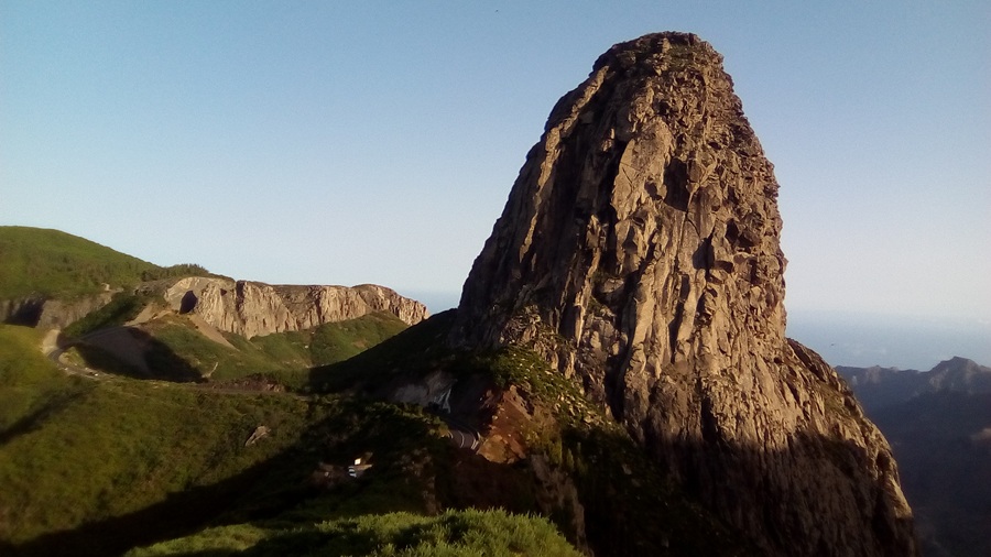
By 7.8 million years ago, volcanic activity waned, and erosion reshaped the topography until the second volcanic sequence began around 5.9 million years ago. For nearly two million years, La Gomera was stripped of hundreds of metres of rock. During this interval, some localised activity persisted, notably in Vallehermoso (8 a 6,4 million years), as well as the emplacement of intrusive felsic domes known locally as roques. These intrusions, which never erupted at the surface, formed between 7.5 and 6.4 million years ago (the second trachytic-phonolitic complex, CTF). Today, erosion has exposed them, revealing harder bodies such as Roque de Agando.
Finally, between 6.4 and 5 million years ago, the Vallehermoso stratovolcano (EAS) collapsed into its underlying magma chamber.
Volcanic Sequence 2 (ER I and ER II)
Erosion from the previous phase carved deep valleys, which now awaited infilling by new lava flows. This was achieved through the basalts of two new volcanic edifices: the first, hereafter referred to as Recent Edifice I (ER I), and the second, Recent Edifice II (ER II). ER I grew between 5.9 and 4.9 million years ago, while ER II developed between 4.7 and 3.4 million years ago. During the development of ER I, eruptions were so frequent that they produced tens of metres of lava flows, known as the Horizontal Basalts, which today form the island’s entire central plateau. The eruptive centres for these flows were located around Alto de Garajonay to the north of La Mérica and west of San Sebastián de La Gomera.
Here too, volcanism evolved from less to more explosive activity, progressing from basalts to phonolites. At the end of this effusive phase, the Vallehermoso area collapsed over the soft substrate above a rising felsic dome. This catastrophic event produced the large volume of breccias surrounding Vallehermoso approximately five million years ago.
Subsequently, residual magma ascent generated a series of radial dykes across the highlands of Garajonay and towards the coast. Some of these, along with additional Horizontal Basalts, inundated the Vallehermoso basin, overflowing to the south and southwest between 5 and 4.2 million years ago. The overall network of dykes, driven by magma ascent stresses, induced radial tensions across La Gomera, forming the characteristic “Mercedes star” pattern of the shields. However, this radial dyke system is truncated to the north by the major Garajonay landslide and subsequent collapses and erosional events. Associated with the ascent along this radial fracture system, felsic domes were emplaced at depth between 4.5 and 4.3 million years ago, forming the so-called Third Trachytic-Phonolitic Complex (CTF III), which, like its predecessors, remained buried until erosion eventually exhumed them.
This accumulation of lava flows, dykes, and domes created extensive unstable slopes around the island, increasing the risk of large-scale landslides. One such event occurred during historical times in the present-day Agulo valley, but many others likely took place around 4.5 million years ago. The apparent disappearance of the radial dykes and the Basal Complex as if something had sliced off the northern part of the island, combined with cliffs outlining a straighter and younger northern coast relative to the south, suggests that multiple landslides progressively eroded more parts of La Gomera around 4.5 million years ago.
During the terminal phase of this second volcanic sequence, erosion again dominated, erasing all volcanic cones, inverting topography, enhancing the central plateau of Horizontal Basalts, exhuming phonolitic roques, and carving the deep present-day valleys. This process removed hundreds of metres of rock, depositing it into the sea. This unloading may have contributed to La Gomera’s isostatic uplift, as suggested by submarine pillow lavas tens of metres above current sea level, deeply emplaced domes now exposed as roques, and the schistosity observed in some rocks such as those at Punta Llana.
Final eruptions
Sporadically, during the past 2.8 million years, when erosion dominated, a few local eruptions occurred. These events were minor compared to the previous phases. Between 2.8 and 2.3 million years ago, volcanic activity included pyroclastic flows, trachytic lava flows, and fumarolic activity. The last and only cone of the island, located in the south—La Caldera—formed around 2.3 million years ago, producing trachytes. Records also indicate a final local eruption around 1.9 million years ago. Erosion continues to shape the island today, while volcanism remains dormant. Meanwhile, El Hierro and La Palma are now taking over La Gomera’s relief in their shield-building phases.
Source: educational EVIDENCE
Rights: Creative Commons