
- Science
- 3 de February de 2026
- No Comment
- 6 minutes read
Floods in Alcanar
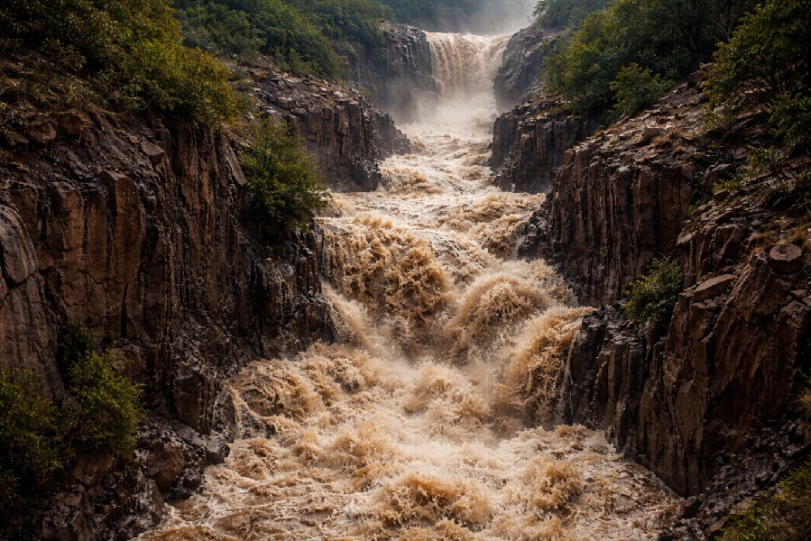
Image created by AI

When 50 per cent of a municipality has been urbanised on flood-prone land, and this has been the case for decades, the consequences for both climate and territory are deeply troubling. The frequent floods at the foot of the Montsià massif in 2018, 2021, 2023 and again in 2025 are clear examples. The torrents that originate in the Cretaceous limestone of the Montsià have acted as natural collectors, channelling water downstream and inundating Les Cases d’Alcanar, the Els Alfacs campsite and Sant Carles de la Ràpita. More specifically, the Sant Jaume, Llop and Codonyol torrents have been the main protagonists of these events.
Responsibility should not be laid, as many media outlets and ideologues insist, at the door of climate change alone. The causes are natural, yes, but they have been dangerously amplified by the clumsy practices of a species known as humans.
Among the natural and distinctive features of our geography and climate are the following: extremely short torrents that discharge their flows almost immediately into the coastal plain; small, steep catchments that fill very rapidly with runoff; sparse vegetation that does little to encourage infiltration or to cushion flash floods; steep slopes descending from the Montsià that promote high flow velocities; clay-rich soils at the foot of the torrents that generate intense surface runoff; weakly incised channels on the coastal plain; and, finally, frequent convective rainfall associated with easterly winds, which cause storms to build up against the wall of the Montsià. In short, a natural powder keg — one that was turned into a nuclear bomb when the urban development plans of the 1960s and 1970s colonised the once-untouched plains at the foot of the range, straightening and walling the channels, increasing water speed and dramatically raising the risk of overflow.
Two further factors must be added. First, the removal of many secondary torrents to expand and maintain agricultural land, which ultimately increases discharge into the main channel. Second, the construction of roads and bridges that cut across these channels, creating ill-placed barriers that are frequently overtopped during floods. A clear example is the N-340 road, which blocks the natural course of the Llop torrent.
In such a context, rainfall approaching 200 litres per square metre is enough to unleash a truly Wagnerian spectacle — especially when antecedent conditions have already saturated the soil, leaving no room for infiltration. This was the case in the 2021 floods, preceded by 85 litres per square metre of rain, and again in 2025, after just 12 litres. The evidence is clear in the very short time lapse between peak rainfall intensity and peak discharge: the catchment response is so rapid that any attempt to warn downstream populations becomes a mere illusion. Hydrological models and flood-risk maps agree on this point, and their conclusions are sobering: we will continue to suffer major and catastrophic floods in the future.
Fortunately, and in a pioneering move, a technical round table was convened in 2025, bringing together experts, local residents and those directly affected. The initiative was launched by Alcanar Town Council, which put forward sound proposals that now need to be implemented throughout 2026 and the years ahead. These include the construction of sediment barriers, flood-retention basins, the widening of drainage outlets in the Alfacs area, and the expropriation of dwellings that are repeatedly subjected to catastrophic flooding. Clearly, such measures require substantial budgets, as well as political will and public resources. The tools are there: strong European directives on risk assessment, and a solid governmental framework for regulating and implementing appropriate measures.
Moreover, under the National Hydrological Plan, a significant share of responsibility lies with local authorities, which have the legal power to expropriate and relocate housing. Channels can also be split or secondary channels created to distribute flood flows more effectively — as was done, for example, on the River Garonne in 2013. What we cannot afford is the widespread and mistaken belief that disasters take a long time to recur, and that all that is required is to repair the damage and restore things to how they were before.
In short, the floods affecting Les Cases d’Alcanar and neighbouring towns have not been exclusively — or even primarily — a matter of climate change. Far more significant has been the human-driven increase in exposure to risk. Many point to signs that rainfall intensity may be increasing, along with the likelihood of more frequent floods in the future. Yet the language used remains cautious and evasive: “it seems that”, “there appears to be a trend”, “it cannot be stated with certainty”. The immediate response to ‘Alcanar under water’ therefore lies in tailored solutions, designed for each specific territory. What is needed, above all, is local risk management — not abstract appeals to global climate change.
Source: educational EVIDENCE
Rights: Creative Commons